#33 The Exciting Drive at Gotthard Pass in Swiss Alps πŸ›€ πŸ‡¨πŸ‡­ θ‘Œι©Άεœ¨ε…¨ηƒζœ€ι•Ώηš„ιš§ι“ε±±ε£

74FF31FD-93CE-4596-AD8A-E7D52F87B91A.jpeg

2C2FE840-8A6D-426F-88CD-8998029879CA.jpeg

I captured this part of the Gotthard Pass during a road trip in Europe. What a slow but exciting ride along these curves in the rain! 💪🚗

这张照片是在欧洲一次自驾途中拍的。照片中蜿蜒的山路在瑞士的阿尔卑斯山区。是不是有点山路十八弯的赶脚?哈哈,雨天在这种路上缓慢行驶还是挺刺激的呢!

It’s an important mountain pass in the Alps at 2,106 m, so it’s pretty cool(literally as well ;) up there. It is connecting northern and southern Switzerland, and is crossed by three long traffic tunnels, each being the world’s longest at the time of their construction: the Gotthard Rail Tunnel (1882), the Gotthard Road Tunnel (1980) and the Gotthard Base Tunnel (2016).

这道重要的隘口海拔2106米,当时从温暖如春(中欧地区这好脾气的夏天,呵呵)的山脚下一路开上去,到了顶上着实有点儿高处不胜寒。这山口贯通了瑞士南北,有三条交通隧道穿过。其中每条在建的隧道都是当时世界上最长的:1882年建成的戈特哈德铁路隧道,1980年建成的戈特哈德公路隧道,还有2016年最新完工的戈特哈德基线隧道。

This pass is not far from the well-known city Lucerne, and it extends between the Italian-speaking part and the German-speaking part of the country.

这个山口离有名的旅游城市卢塞恩不远,位于瑞士意大利语区和德语区之间。

Have you ever been here or to other beautiful mountain passes? Please tell me your experiences in the comments below! 😃

不知道你有没有在这条山路,或其他类似的曲折曼妙的道路上行驶过?=) 快快留言告诉我哦!


Thank you for reading. =) Check out my recent posts below, and follow me for more!

##
Hong Kong Star Ferry Crossing at Sunset 暮色中的维港和天星小轮

Traditional Clothing in Peru’s Colca Canyon 秘鲁大峡谷山民的传统服装长什么样?

Explore Easter Island with Me (1) - Introduction and Anakena 复活节岛摩托之旅(一)

@ItchyfeetDonica is my only account here and I’m 200% real ;) → Introduce Cross-culture Me on This Cross-over Platform 处女贴-自我介绍

Here are some screenshots from my Instagram. Follow @ItchyfeetDonica for more shots around the globe!


!steemitworldmap 46.557886 lat 8.565044 long Gotthard Pass d3scr


This page is synchronized from the post: ‘#33 The Exciting Drive at Gotthard Pass in Swiss Alps 🛤 🇨🇭 行驶在全球最长的隧道山口’

#32 Explore Easter Island with Me (1) - Introduction and Anakena πŸ—ΏπŸ‡¨πŸ‡± ε€ζ΄»θŠ‚ε²›ζ‘©ζ‰˜δΉ‹ζ—…οΌˆδΈ€οΌ‰

AD1A75B9-E76F-4409-AB40-7E296BD49A96.jpeg

All texts and images(without me) are by @itchyfeetdonica | 图文 by Donica

When you hear “Easter Island”, what pops up in your mind? When I type this place name in my phone, this icon🗿 appears on the list. Right! It’s moai, the enigmatic giant stone figures created by the early Rapa Nui people. But of course there are much more than these monumental statues on this enchanting volcanic island. So I’m going to show you some fragments through my 9-day traveling on the island. Today let’s start from the introduction and Anakena, the cradle of Easter Island’s history and culture.

3C7BA426-5907-46C8-8516-227A35BFEE4A.jpeg

Before I start talking about my experience on the island, I’d like to make clear first some concepts that puzzled me a bit before I traveled there. Hopefully it could be helpful to you too in understanding better the Polynesian and Rapa Nui cultures.

There are three major cultural areas in the Pacific Ocean: Micronesia, Melanesia and Polynesia. As you can see from this picture I took in the Anthropology Museum on the island: Easter Island is at the southeastern vertice of the Polynesian Triangle in Oceania. 👇

02AEDBAB-6A14-4D53-931B-B3830DDDBE7D.jpeg

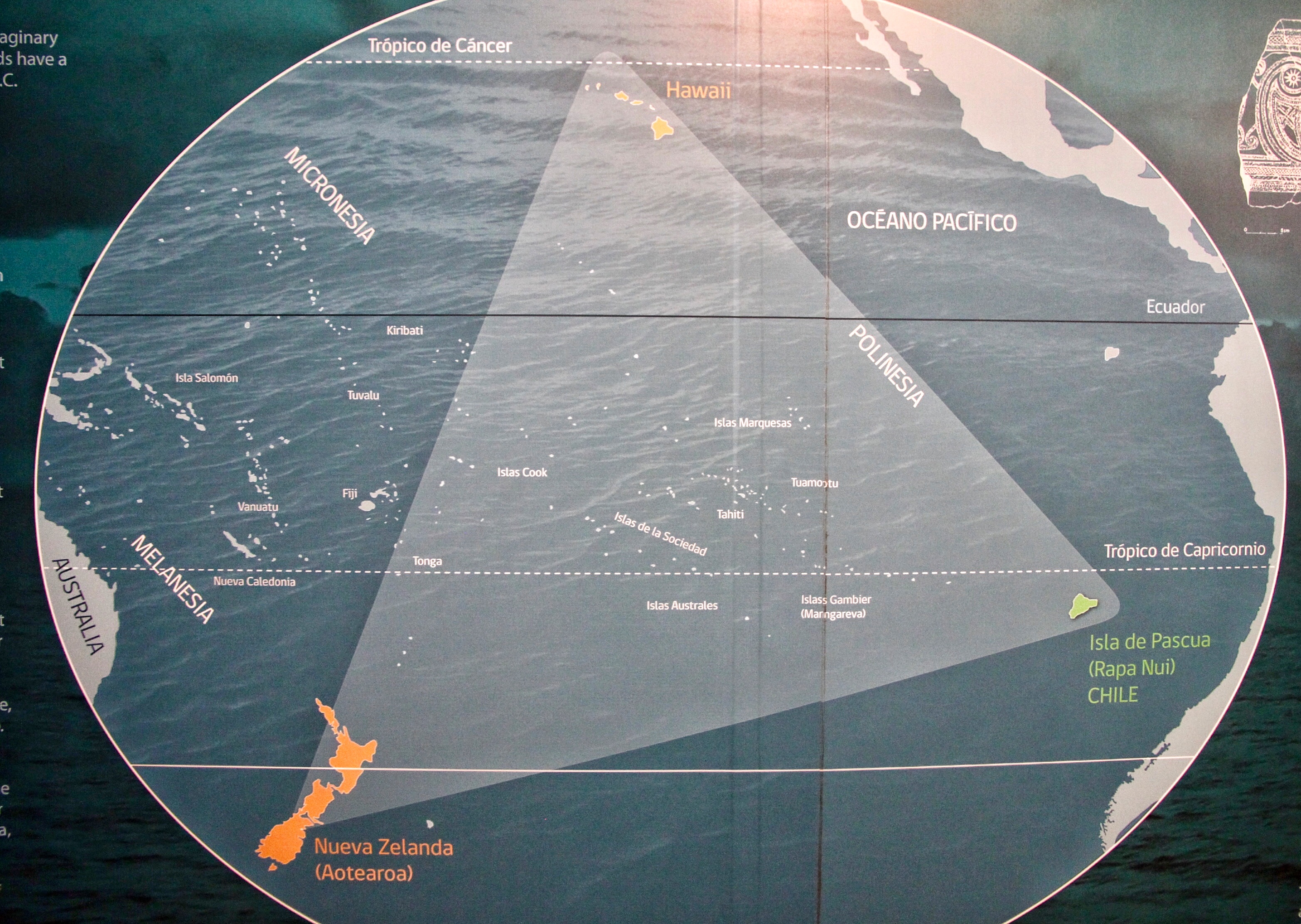
Around 500 BC, the first Polynesians set sail in their big canoes 🛶 on a colonization adventure. From Tonga, Samoa and other adjacent islands, they reached and populated the Cook Islands, Tahiti and other islands. After another 700 years, they sailed to different directions and closed the Polynesian Triangle by colonizing its three extremes: Hawai’i (Sandwich Islands) between 200 and 400 AD, Rapa Nui (Easter Island) between 800 and 1200 AD and Aotearoa (New Zealand) between 800 and 1000 AD.

After the population phase on Easter Island, it came the classic era when the Rapa Nui culture reached its peak with the construction of the huge ceremonial centers and moai statues. Then at around 17th century, conflicts started between the different lineages. Moai were toppled and the Tangata Manu (birdman) ritual sprang up, until the arrival of Catholic missionaries in 1864.

E21511E1-4CC1-4FE9-94EF-9FC03BD07E75.jpeg

I’m lucky to have worked in Chile and traveled to Easter Island which was annexed by Chile in 1888. It’s a flight around 5 hours by LAN Airlines (now LATAM Airlines, the only operator flying from the South America continent) from Santiago to Hanga Roa, kind of the capital town, the settlement with most residents.

You can also fly from Tahiti(less frequent flights), or take a more intrepid route - once a year, you’ve got the chance to sail the “tall ship” Soren Larsen to Easter Island from New Zealand. This great voyage takes 35 days, crossing the point on earth furthest from land. Sounds epic right? Just takes some time, courage and patience ;)

5DA6D00C-DCFA-40C9-AB24-8E1C3F6C6D4F.jpeg

The high season of tourism on Easter Island is normally from December to March, the warmest time on the island, and the coldest time in the Northern Hemisphere. In late January or early February, there’s the two-week long traditional festival Tapati Rapa Nui drawing crowds of tourists. On this annual event, the islanders showcase their skills and crafts in stone and woodcarvings, body-painting and cooking in the Polynesian style.

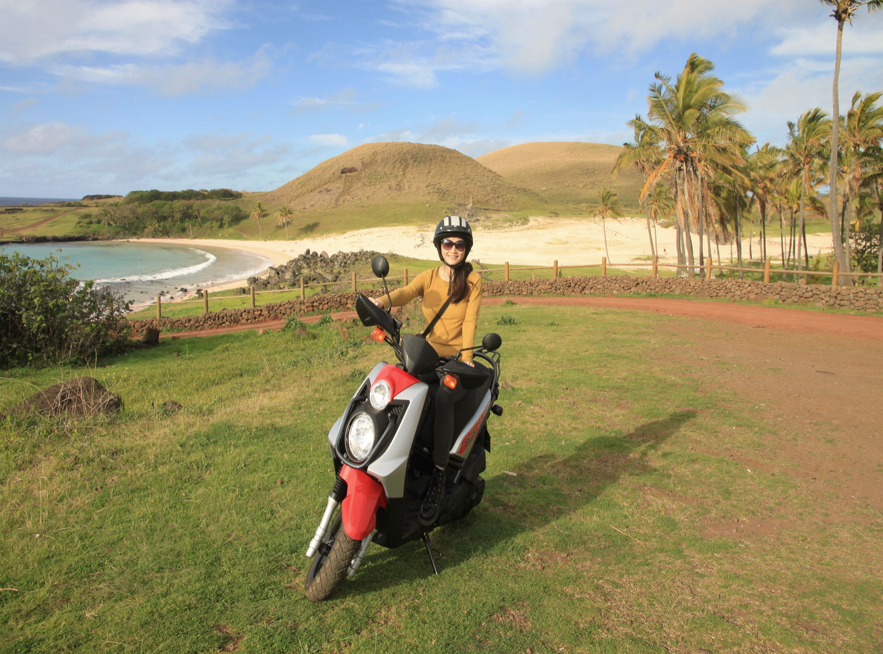
We rent a motor scooter and roamed around the whole island for 9 days in August. You might think it’s too long to stay on a small island like this. But we explored almost all corners of it, and enjoyed it a lot during the off season when there were not many tourists. We even got upgraded to first class in the flight back to Santiago de Chile, because the airplane was almost empty. What a pleasant surprise to be served a little piece of succulent steak, paired with the fantastic Chilean wine! ; )

336048AF-2CBA-4F3D-9050-DE316DBD8D8F.jpeg

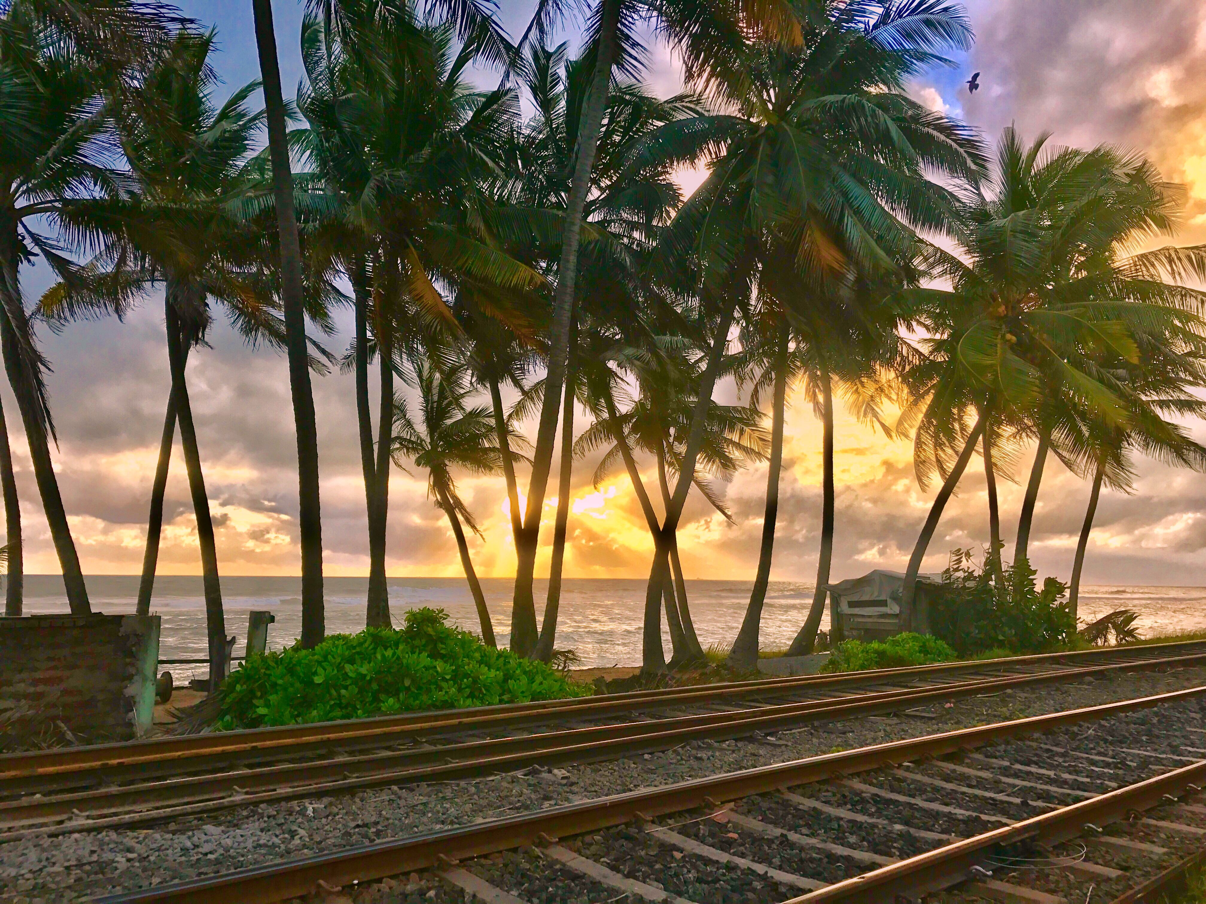
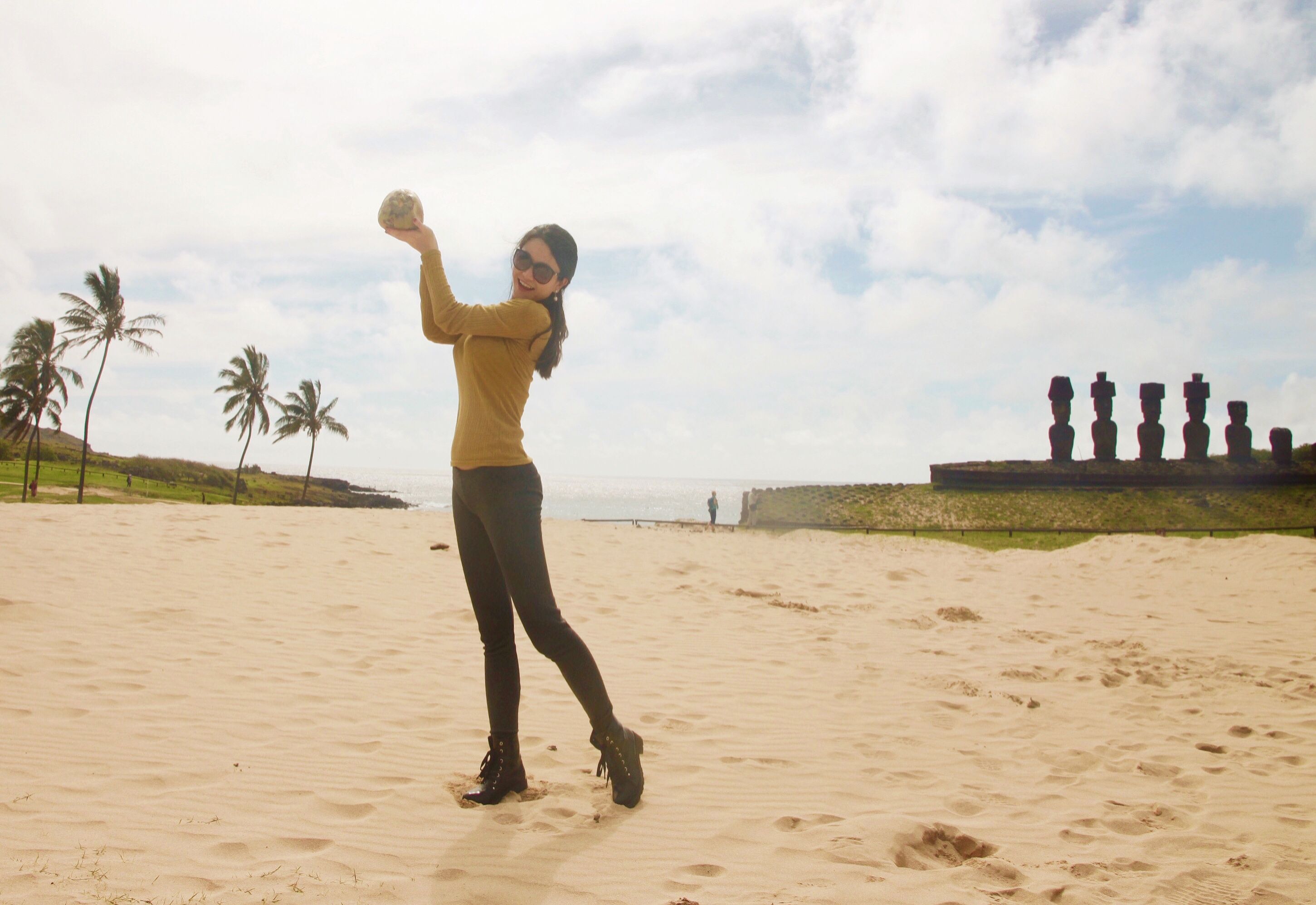
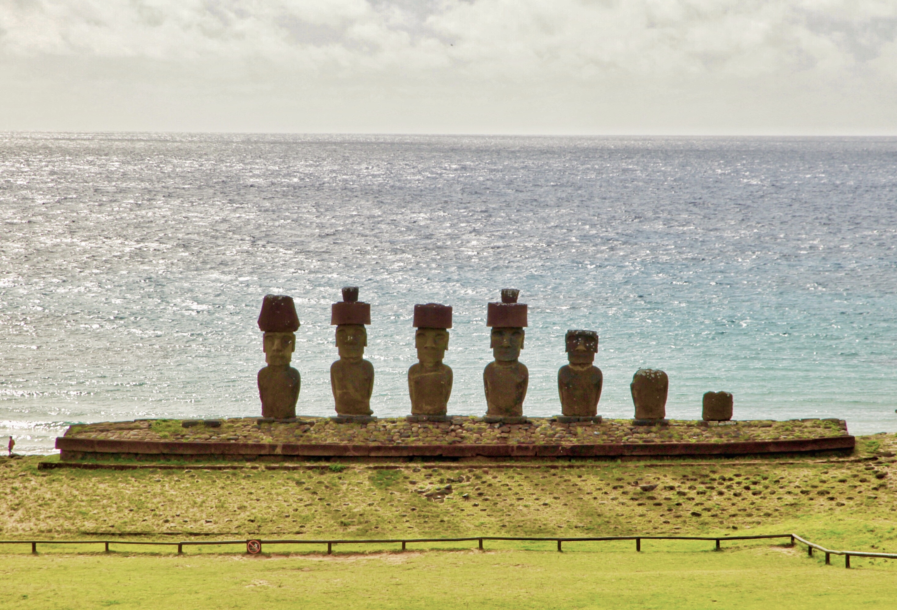
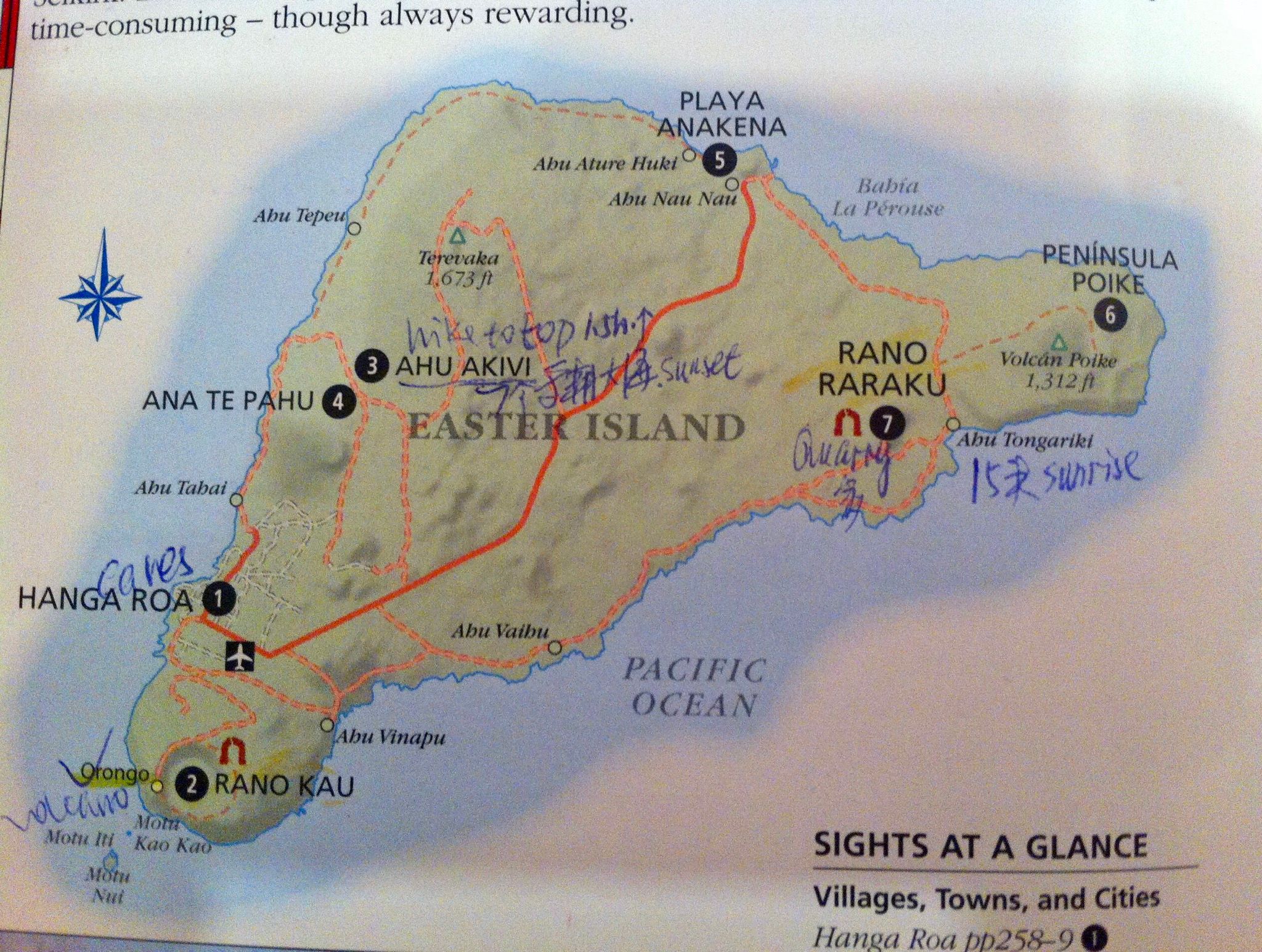
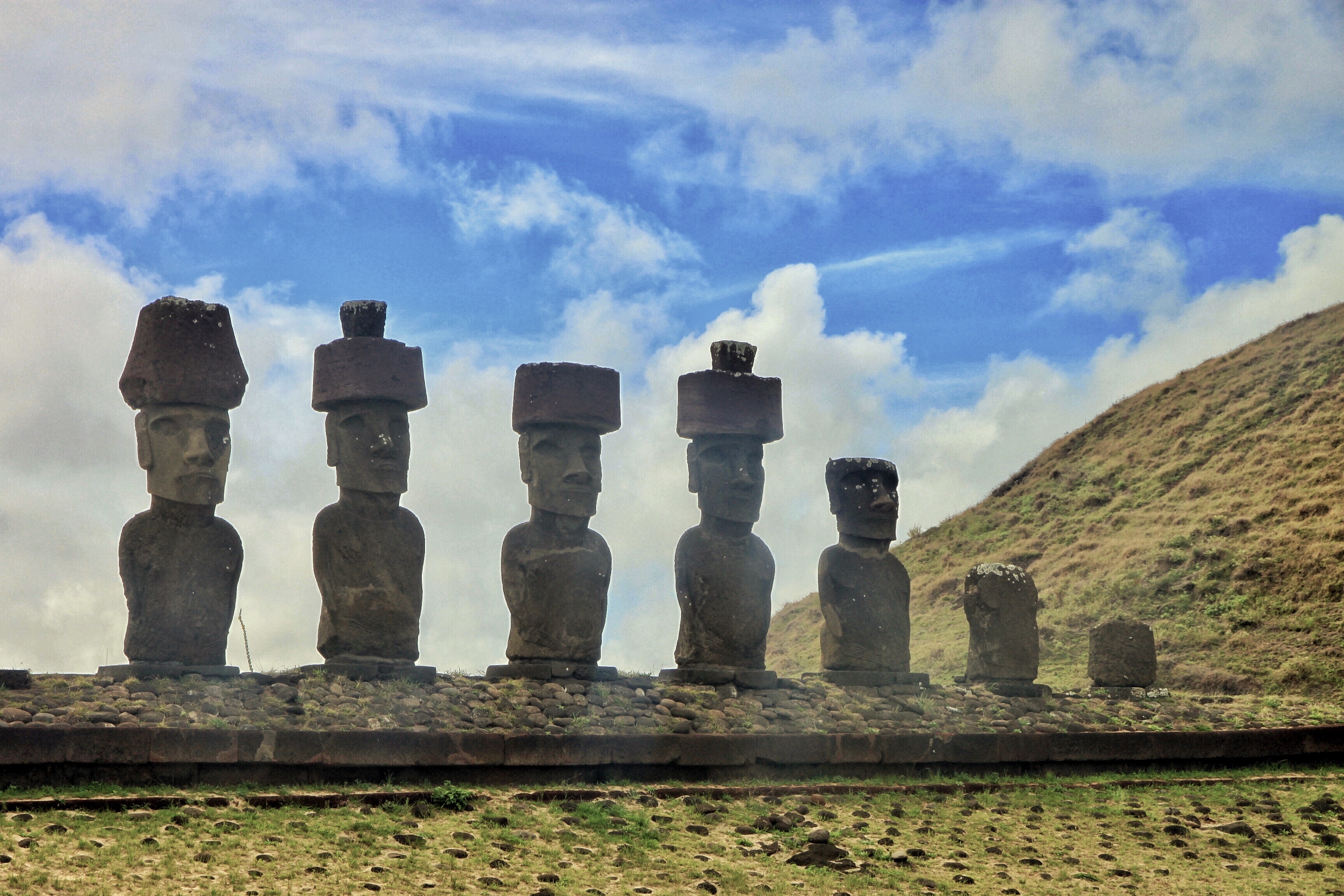
From the picture below(shot from my DK travel book of Chile), you can see that the overall shape of Easter Island is triangular. The main and only village Hanga Roa is located at the southwest. The photos in this post were all taken at the site number 5 - Playa(beach) Anakena. 👇

01C5E0A7-834A-48BD-A1DF-40DD35CDBB98.jpeg

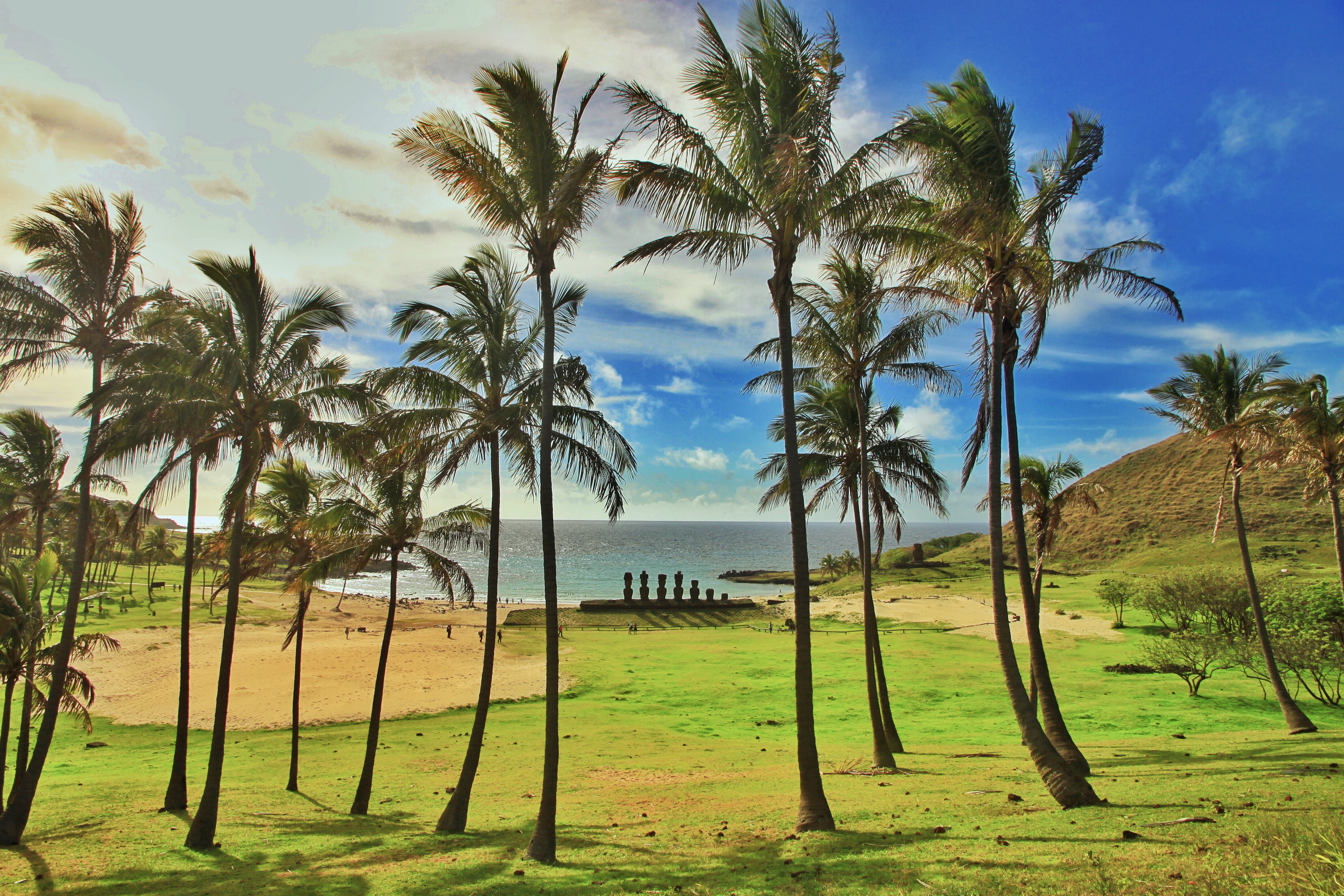
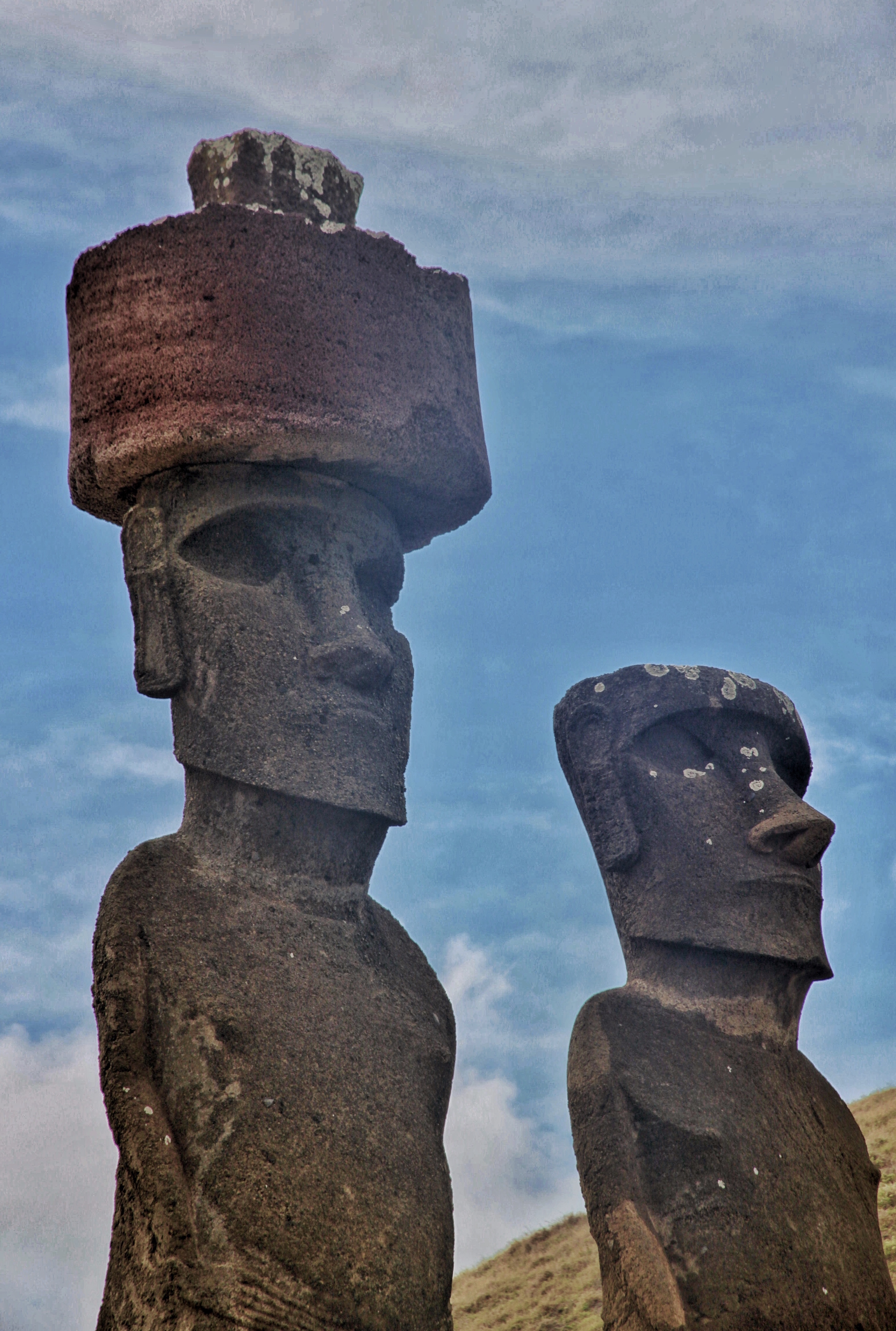
Anakena has two ahus(ceremonial platforms); Ahu Ature Huki has a single moai(the giant monolithic stone statue), and Ahu Nau Nau has seven moai statues, two of which have deteriorated. 👇

418018A5-E07E-4EF2-8377-87BA9DFFD931.jpeg

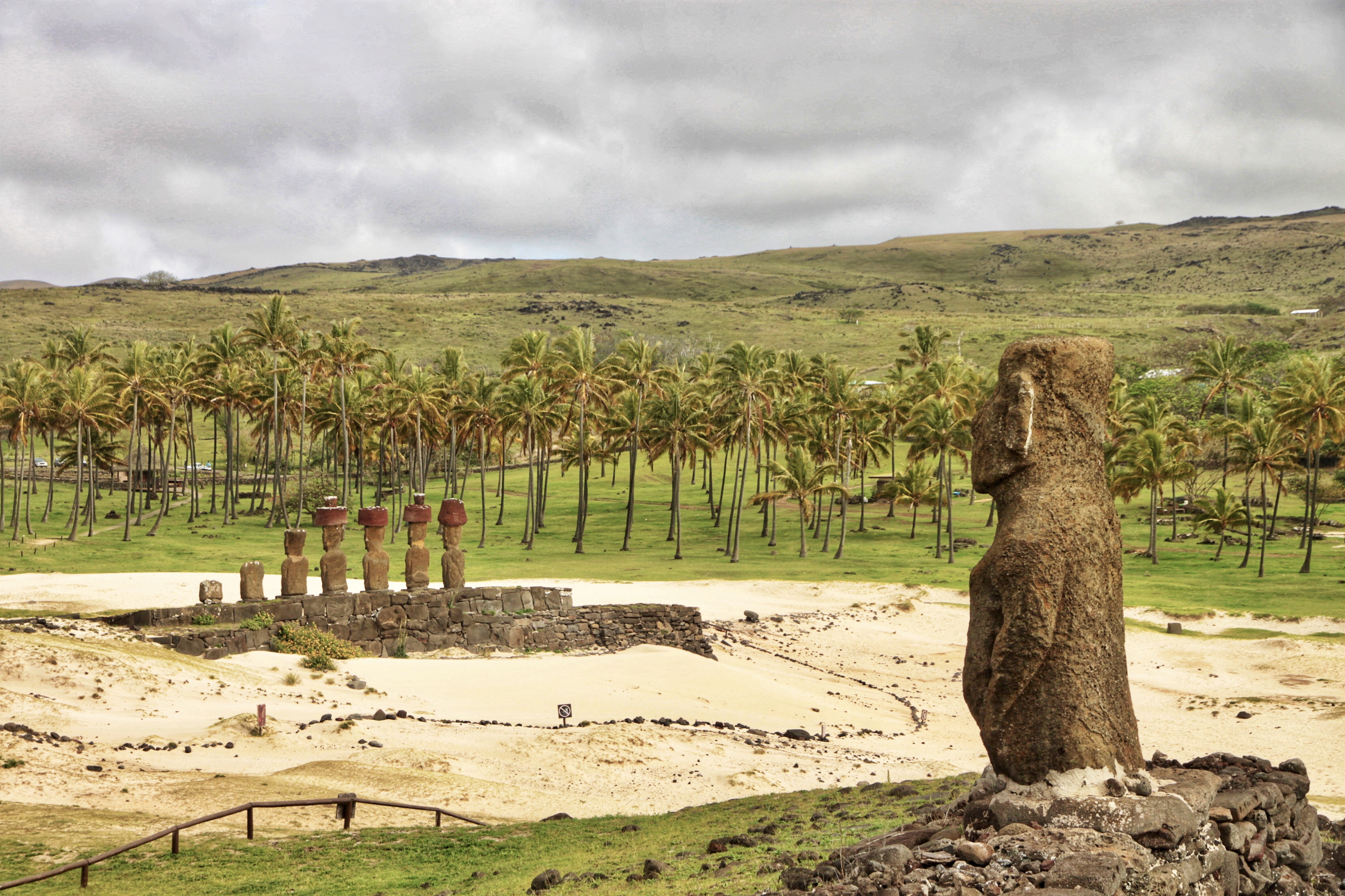
Anakena is the only tropical coral sand beach on the island that is good for swimming and sunbathing. The other beaches here are actually pretty rough, mostly with rocks, cliffs and strong waves. Surrounded by palm trees, it’s a great place to relax and to click some pretty shots.

A3CC3FBF-76FE-46A6-9097-8987CA7AC82E.jpeg

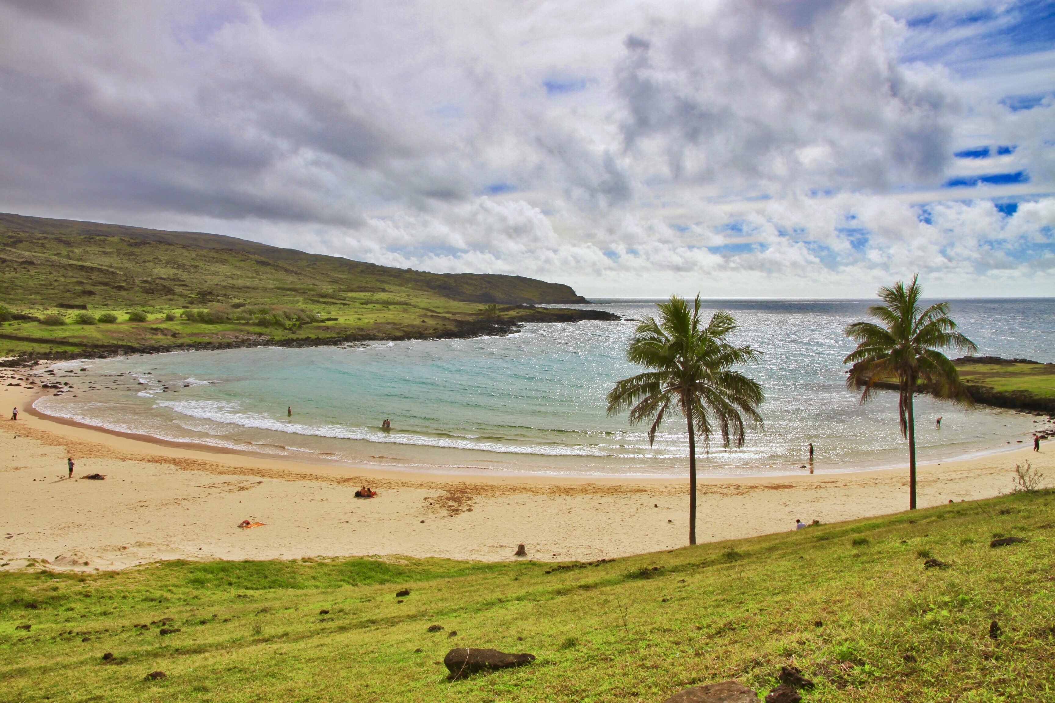
Anakena is known as “The Bay of The King”, named after the founding Rapa Nui king Hotu Matu’a who set foot on the island when it was first populated. This was where king Hotu Matu’a built his first house, and it remained the sacred land of the royal family.

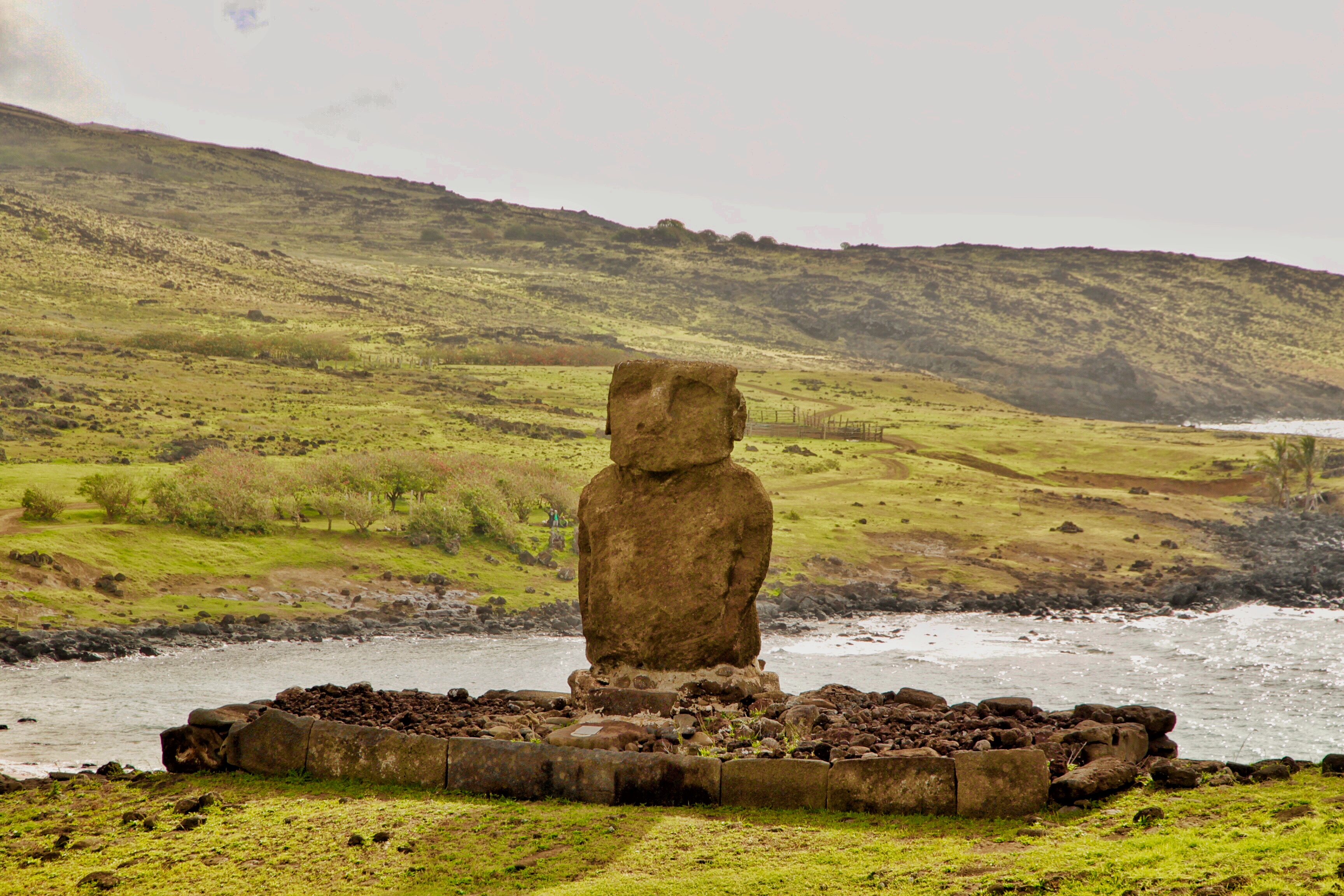
The single moai of Ahu Ature Huki is the first moai statue ever to be restored by Norwegian explorer Thor Heyerdahl in 1956. The moai was raised by using only rocks, logs and rope. The logs were used as levers to lift the statue and rocks were put underneath, raising the statue little by little. 👇

FDA59A3F-E4BE-4A15-929F-83F5A3FA902E.jpeg

This whole vicinity in Anakena is a dense archeological site. It contains ceremonial centers both above and under the ground. So it’s of vital importance for understanding this mysterious island’s past.

0D5350BE-952E-49B8-839B-78A316DB0C48.jpeg

That’s it for my first post about Easter Island. Hope you enjoyed it. Have you ever visited this remote island? What did you do there? Tell me what you think in the comments below! 😃 See you next time!


Thank you for reading. Check out my recent posts below, and follow me for more! =)

##
Hong Kong Star Ferry Crossing at Sunset 暮色中的维多利亚港和天星小轮

Traditional Clothing in Peru’s Colca Canyon 秘鲁大峡谷山民的传统服装长什么样?

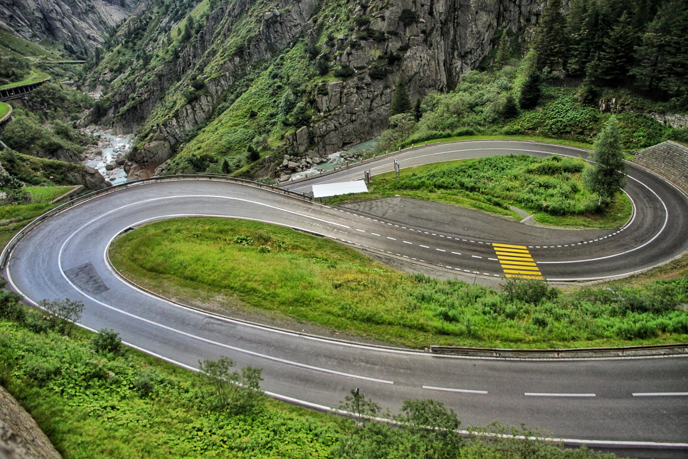
The Exciting Drive at Gotthard Pass in Swiss Alps 行驶在全球最长的隧道山口

@ItchyfeetDonica is my only account here and I’m 200% real ;) → Introduce Cross-culture Me on This Cross-over Platform 处女贴-自我介绍

Here are some screenshots from my Instagram. Follow @ItchyfeetDonica for more shots around the globe!


!steemitworldmap -27.074393 lat -109.322484 long Anakena Easter Island d3scr


This page is synchronized from the post: ‘#32 Explore Easter Island with Me (1) - Introduction and Anakena 🗿🇨🇱 复活节岛摩托之旅(一)’

#31 Train Travels in Sri Lanka (1)πŸ‡±πŸ‡° ζ–―ι‡Œε…°ε‘ηš„η«θ½¦ζ—…θ‘ŒοΌˆδΈ€οΌ‰

F89416DE-55EB-4C3D-AF14-2FAE767DED58.jpeg

All images and texts by @itchyfeetDonica | 图文 by Donica

Sri Lanka is a fabulous destination for travelers. It has an abundance of culture as well as the natural splendour. I traveled alone there and felt very safe, the local people were friendly and helpful, and it’s relatively easy to get around as a result of the common English speaking. Besides, what the most vital for me is: the food there is tasty and healthy.

斯里兰卡是我最喜欢的旅行目的地之一。这里不仅有美不胜收的自然风光,也有悠久灿烂的历史文化。更关键的是:各种美食也是可口又健康。我在那里独自旅行了几周,觉得很安全,当地人大多是佛教徒,非常友好和善,而且由于它是前英国殖民地,英语普及,到处走起来也没有障碍。

When you visit Sri Lanka, taking the trains 🚊 is definitely something you shouldn’t miss. It’s an inexpensive way to get around, and the trains are going through some beautiful scenic area, packed with fun cultural experiences as well.

如果你去斯里兰卡,千万别错过乘火车旅行。火车不仅是当地人常用的便宜交通工具,沿途经过的地方也处处是美景。 看看一路上多彩的民居,门前嬉闹的孩童,熙熙攘攘的街市,漫山遍野翠绿的茶园中和乡间田野里劳作的人们。还可以跟旁边座位上的当地人交流交流,粗浅地了解一下别样的生活。或长或短的旅途中,就算你不主动说话,热情的南亚人民通常也会找你聊聊天的。

073E6642-F826-4AAE-9E63-EB5DE2E0A810.jpeg

The initial railway system was built by the British in 1864, mainly to transport tea and coffee from the Tea Country to the capital port city Colombo, so that the produce can be shipped internationally. Today there are train tracks between major towns in Sri Lanka.

最初的列车系统是由英国殖民政府在1864年修建的,主要为了把山区产的茶叶和咖啡运往首都科伦坡的港口,再船运出去。如今,斯里兰卡的主要城镇之间也都有火车线路连接。

The coastal train ride from Colombo to Dutch colonial Galle is popular among tourists and locals alike. You can see the train rails in these photos I took at the Marine Drive, in the south of Colombo. The train in the first photo was probably going to Galle or somewhere in between along the coast.

从首都科伦坡开往南部海滨的荷兰殖民古城加勒的这条沿海火车线路很受游客欢迎。从这些照片里也可见一斑,一边是蔚蓝广阔的印度洋,一边是南亚风情的市井百态,还不时点缀着茂盛葱茏的热带植物,无敌海景配上摇曳多姿的棕榈树,看夕阳缓缓下落,还需要我继续安利吗?; ) 我这里发的照片都是在科伦坡市南郊的滨海道上拍的,第一张照片里的火车应该就是开往南部的某个地方。

6B5E5BBD-6178-4A0F-B11F-04478E0158D1.jpeg

I took the trains from Colombo to Kandy and up into Tea Country, stopped a few days at Nuwara Eliya, Ella and other small villages. Along the train journey, the views of the lush green tea plantations on rolling hills were simply breathtaking. I’d love to post more pictures and details of the train 🚂 journeys, and the interesting experiences of visiting local temples during a festival, the fun cooking lessons, etc., later when I have access to my laptop and portable drive. 🙂 So stay tuned and until next time!

我从科伦坡坐火车一路到了南部中央的坎迪,这个以佛牙寺著称的佛教圣地和文化古都。又继续上到盛产茶叶的山区,在处于斯里兰卡最高点的英伦风情小镇努沃勒埃利耶,还有景色和气候都很宜人的小山村埃拉停留了几天。一路上火车迤逦穿行于苍翠的群山,风光秀美的茶园风光尽收眼底。我在那些小山村里正好赶上宗教节日,跟着当地人去寺庙围观祭祀和发放免费斋饭,还去学了斯里兰卡美食烹饪。等我结束这次澳洲的自驾旅程,会整理一下电脑和移动盘里的照片,继续和大家分享。敬请期待哦!下次再见!

Have you ever been to Sri Lanka? Did you take the trains there? Tell me what you think in the comments below! 😃

你去过斯里兰卡吗?有没有坐过那里的火车?欢迎留言评论!=)


!steemitworldmap 6.914839 lat 79.847946 long Colombo Sri Lanka d3scr


This page is synchronized from the post: ‘#31 Train Travels in Sri Lanka (1)🇱🇰 斯里兰卡的火车旅行(一)’

#30 A Magical Light Show of Vortices Created by Movement πŸ’‘πŸŒ€ι…·η‚«ε₯‡εΉ»ηš„ζΌ©ζΆ‘光影秀

3E5281EC-E16C-4BAA-89B1-1838EBEB54CC.jpeg

06655C82-50C4-4769-9B9F-F3F088CD0E02.jpeg

818AFA6B-F67F-4156-92B4-2ADFA33A1526.jpeg

All images by @itchyfeetDonica
The first one is my entry for the smartphone photography contest themed “light” 💡

| 图文 by Donica (本期手机摄影活动主题: “光”)

中文请下拉👇

What’s up fellow Steemians! Today I’d like to show you an ultra cool interactive digital projection, a work by a Tokyo-based art collective and creative group - teamLab.

9173EBCC-79C9-4846-9C70-202986802063.jpeg

14BB60AC-F5E6-4BF7-BF83-5AC01BAEEE6D.jpeg

6429AAE3-1EEF-49B1-93DD-F3CCD0B8B760.jpeg

I visited this magical space at the NGV (National Gallery of Victoria) Triennial in Melbourne a few days ago. The Triennial is a free exhibition of contemporary art and design practice, showcasing the work of over 100 artists and designers from 32 countries, running from December 15, 2017 until April 15, 2018.

Spanning four floors, this exhibition explores cutting edge technologies, architecture, animation, performance, film, painting, drawing, fashion design, tapestry and sculpture. Used to be a student of Cultural Studies who had a course in art museum for a whole semester, I devoured this Triennial as an absolute feast. 😋

D9D2F25B-9B4F-4F6D-9B2D-FC7103AFD849.jpeg

402148FA-EF2C-4394-84D2-E7C1A14BFD56.jpeg

There are so many amazing creative works, and every piece deserves a post! I’d love to show you a few more artworks in future posts. Now let’s start with this magical light show. Here’s the introduction on the wall which will explain it better than I would:
8C285852-F98A-44BA-BC7F-1A681C107318.jpeg

This interactive projection reminds me of the work - Gleaming Lights of the Souls, by another well-known Japanese artist Yayoi Kusama (Yes I love polka dots too ;D ). I visited this permanent installation in the awesome Art Museum Louisiana in Denmark 🇩🇰 in 2013. I will(should) write about it in a future post! (another cliffhanger ;p)

I tried to upload a video of this light show online, but failed with my mobile data on a campsite (pretty bad connection)😕. I’ll see if I can add it later. Using my phone to post these days is a real pain in the eyes if not in the neck or ass. ; )

Ok, that’s it for now. Hope you like this artwork as well as my post. Until next time! 😁


中文概要:

这场酷炫奇幻的光影秀是东京的创意艺术团体teamLab的交互数码投影作品,是我前几天在墨尔本的维多利亚州国立美术馆三年展上看到的。进入一间昏暗的四面装有镜子的展室后,每次走动,传感器都会记录你的步伐,通过电脑传达给投影仪,再在地面上投射出漩涡🌀,人的运动越快,漩涡也越激烈。如果人保持静止,漩涡也会消失。同时配有深沉舒缓的音乐,仿佛伴着天外之音在太空漫步。可惜我上传视频没有成功,没错,这些天一直是在路上用手机发文,现在又是荒郊野外没什么信号。

这件作品让我想起几年前在丹麦的路易斯安那艺术馆看到的长期装置艺术:“灵魂的闪光”,也是出自日本的艺术家,只是草间弥生更为知名。我很喜欢她那些波尔卡圆点主题的杰作。她在这次三年展上也有作品展出。哎呀,又扯远了。还是改天另贴继续扯好了😉。

这场免费的三年展占据了整个美术馆国际馆的四层楼,筛选了世界最佳艺术和设计作品, 包括前沿技术、建筑、动画、表演、电影、绘画、素描、时尚设计、挂毯和雕塑等, 展出来自32个国家的超过100位艺术家和设计师的杰作。从去年12月15日一直展出至2018年4月15日。

其中还包括两件中国艺术家的展品:徐震的15.8米长的大卧佛和小型古希腊罗马雕塑的神奇混搭, 以及知名时装设计师郭培最新的高级定制礼服作品。

以前读研时,有的课程一学期都是泡在艺术馆里授课,作为一名伪艺术爱好者,在旅途中碰上这样的三年展,还是免费, 真是一场感官盛宴啊。这些极具创意的作品,每一样都可以写一篇长帖,今天就让我先从这场奇幻的光影秀开始吧。如果有读者需要翻译上面黑墙白字的作品英文介绍,尽管留言告诉我。毕竟大家都很忙,也不一定感兴趣,暂且这样吧,呵呵…… 反正我写得很开心,希望你也有所收获。下次见!😃


!steemitworldmap -37.823430 lat 144.969642 long NGV Melbourne d3scr


This page is synchronized from the post: ‘#30 A Magical Light Show of Vortices Created by Movement 💡🌀酷炫奇幻的漩涡光影秀’

#29 Come Explore the Popeye Village with Me! πŸ‡²πŸ‡Ή ι©¬θ€³δ»–ζœ‰δΈͺε€§εŠ›ζ°΄ζ‰‹ζ‘

Hello Steemians! Have you ever watched the old movie Popeye starring Robin Williams? Do you know where the film set is?

The answer is… Anchor Bay, Malta! As you can see from this picture, the Popeye Village consists of colorful rustic wooden houses and pathways. It was designed by Danish architect Hans Munk Hansen. So it’s also called Danish Village or Sweethaven Village.

DDC5253A-C051-44D3-8F4D-340FA821085D.jpeg

👆by @itchyfeetDonica
6A32B63D-FFBF-43C4-90C2-7052ADD68035.jpeg

Today it is converted into an attraction fun park and it is open to the public as an open-air museum. There are shows and rides, as well as play houses where children can climb and explore the village. You may also get to meet the main characters from the show such as Popeye, Olive Oyl, Bluto and Wimpy. In some of the houses, you can find props used in the film’s production.

If you visit this place, don’t miss the chance of taking a twenty-minute boat trip around Anchor Bay, so you can view the village from the sea. If you want to try diving, this is also a great spot for it!


!steemitworldmap 35.960952 lat 14.341149 long Anchor Bay Malta d3scr


This page is synchronized from the post: ‘#29 Come Explore the Popeye Village with Me! 🇲🇹 马耳他有个大力水手村’

#28 Discover with Me the Ethiopian Rift Valley Lake Region πŸ‡ͺπŸ‡Ή θŠθŠδΈœιžε€§θ£‚θ°·εŒ—ιƒ¨ζΉ–εŒΊ

4312B8D0-DF43-47CC-8DEC-6980A1BA696D.jpeg

The pictures in this post are shot by me near Lake Abaya, the biggest Ethiopian Rift Valley lake. You might have heard of East African Rift Valley, and the Rift Valley lakes in Ethiopia are the northernmost of the African Rift Valley lakes. This group of lakes in the East African Rift runs north-south through the continent, from Ethiopia in the north to Malawi in the south.

In central Ethiopia, the Great Rift Valley splits the Ethiopian highlands into northern and southern halves, and the lakes occupy the valley floor between the two highlands.

997D551B-854E-493B-8D8D-537F811A7559.jpeg

This is a beautiful region surrounded by green rolling hills, and it’s full of banana plantations, pineapple plants, and mango and guava trees. The local people live a pastoral life, herding cows and growing fruits.

F642839C-3B16-4121-BDCB-77E284C5346D.jpeg

Locals use these colorful tanks for carrying water. It was pretty hot when I was there, so I believe it’s not an easy job for the kids and women to carry the heavy water tanks in the scorching sun.

E9EFA839-756D-4BEB-BF60-91BF12FECF24.jpeg

99CBA950-0C13-4613-868F-30D8E295BF62.jpeg

The closest big town is Arba Minch. It’s known for its fish farms, and it also supplies fruits to the whole country. There is a university in this town which is well-known nationwide. The town is served by Arba Minch Airport. Some tourists fly directly here to travel in the south instead of first going to the capital city Addis Ababa.

Arba Minch is a good base to explore the amazing Nechisar National Park, where zebras 🦓 and gazelles roam the vast savannahs. 2 biggest Ethiopian Rift Valley lakes - Lake Abaya and Lake Chamo are also close by. I did a boat tour to these lakes and watched hippos, crocodiles and lots of water birds. It’s also the gateway for going further south to the 2 national parks: Omo and Mago, where you can see the interesting wildlife and experience the unique tribe cultures.

668CBDD0-D06C-4ABA-BEF0-3C89C6A4293C.jpeg


!steemitworldmap 6.105053 lat 37.567749 long d3scr


This page is synchronized from the post: ‘#28 Discover with Me the Ethiopian Rift Valley Lake Region 🇪🇹 聊聊东非大裂谷北部湖区’

Your browser is out-of-date!

Update your browser to view this website correctly. Update my browser now

×